
คุณูปการ.
ด้านวางรากฐานการศึกษาโบราณคดีสมัยใหม่
รายละเอียดเพิ่มเติม
ด้านการสร้างองค์ความรู้ด้านประวัติศาสตร์และโบราณคดีอยุธยา
รายละเอียดเพิ่มเติม
ด้านงานพิพิธภัณฑ์
รายละเอียดเพิ่มเติม
|
 |
๑.๒ การจัดทำแผนที่สมัยใหม่ในงานโบราณคดี พระยาโบราณราชธานินทร์ได้ทำการสำรวจ และจัดทำแผนที่ เพื่อกำหนดตำแหน่งภูมิสถานกรุงศรีอยุธยา นับเป็นแผนที่ฉบับแรกอันเป็นผลมาจากการศึกษาประวัติศาสตร์และโบราณคดีอย่างเป็นระบบ ซึ่งเป็นฐานข้อมูลสำคัญด้านอยุธยาศึกษา อีกทั้งยังเป็นข้อมูลสำคัญที่กรมศิลปากรใช้ในการกำหนดขอบเขตโบราณสถาน จนนำไปสู่การขึ้นทะเบียนโบราณสถานเกาะเมืองพระนครศรีอยุธยา และจัดตั้งนครประวัติศาสตร์พระนครศรีอยุธยา |
๑.๓ การสงวนรักษาพื้นที่เมืองอยุธยาให้เป็นสาธารณสมบัติของแผ่นดินตามพระบรมราชโองการของพระบาทสมเด็จพระจุลจอมเกล้าเจ้าอยู่หัว โดยการบริหารจัดการพื้นที่และกำหนดเขตเพื่อป้องกันการบุกรุกทำลาย ส่งผลให้หลักฐานทางโบราณคดีและโบราณสถานยังคงปรากฎร่องรอยหลักฐานอยู่จนถึงในปัจจุบัน เป็นแหล่งเรียนรู้ของสาธารณชน และเข้าหลักเกณฑ์พื้นที่ที่ยังคงหลงเหลือร่องรอยเป็นของแท้ดั้งเดิมมีเอกลักษณ์โดดเด่นและทรงคุณค่าของอารยธรรมเมืองมรดกโลกขององค์การยูเนสโก
 ๒. การสร้างองค์ความรู้ด้านประวัติศาสตร์และโบราณคดีอยุธยา
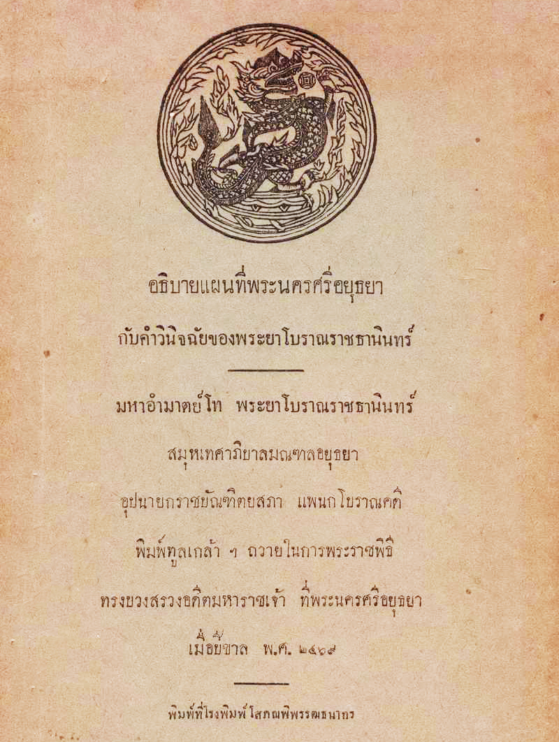
พระยาโบราณราชธานินทร์เป็นผู้วางรากฐานงานวิชาการด้านอยุธยาศึกษา โดยบูรณาการความรู้ทางประวัติศาสตร์และโบราณคดีอย่างเป็นระบบ ผลงานนิพนธ์ที่สำคัญคือ “ตำนานกรุงเก่า” “อธิบายแผนที่พระนครศรีอยุธยากับคำวินิจฉัยของพระยาโบราณราชธานินทร์” “ภูมิสถานกรุงศรีอยุธยา” ซึ่งเป็นการศึกษาค้นคว้าประวัติศาสตร์อยุธยาและผลการสำรวจสภาพภูมิสถานที่ปรากฎร่องรอยในช่วงเวลาดังกล่าวพร้อมกับกำหนดตำแหน่งที่ตั้งของสถานที่สำคัญต่าง ๆ อันเป็นคู่มือในการศึกษาประวัติศาสตร์และโบราณคดีอยุธยาในเวลาต่อมา
๓. เป็นผู้ให้กำเนิดงานพิพิธภัณฑ์ในส่วนภูมิภาค
พระยาโบราณราชธานินทร์เป็นผู้รวบรวม สงวนรักษา อนุรักษ์ศิลปวัตถุ โบราณวัตถุ ซึ่งได้จากการสำรวจขุดค้นในพื้นที่เมืองอยุธยานำมาจัดหมวดหมู่ จัดแสดง และก่อตั้งเป็นอยุธยาพิพิธภัณฑ์ ซึ่งมีความทันสมัยสอดคล้องกับหลักวิชาพิพิธภัณฑ์สากล อยุธยาพิพิธภัณฑ์ เป็นพิพิธภัณฑสถานส่วนภูมิภาคแห่งแรกของไทย ต่อมาพัฒนาเป็นพิพิธภัณฑสถานแห่งชาติ จันทรเกษม
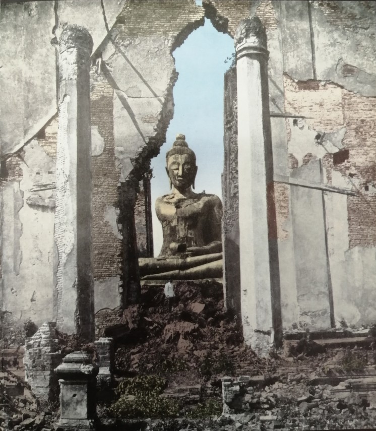
การรวบรวมโบราณวัตถุ ศิลปวัตถุของพระยาโบราณราชธานินทร์ในอยุธยาพิพิธภัณฑสถานมีคุณูปการต่อการศึกษาด้านประวัติศาสตร์ศิลปะ โบราณคดี และพิพิธภัณฑสถานของไทย เพราะเป็นโบราณวัตถุ ศิลปวัตถุชิ้นเยี่ยมและเป็นตัวแทนของยุคสมัย เช่น เศียรพระพุทธรูปวัดธรรมิกราช และพระพุทธรูปลีลาที่มีจารึกเก่าที่สุดสมัยอยุธยา เป็นต้น
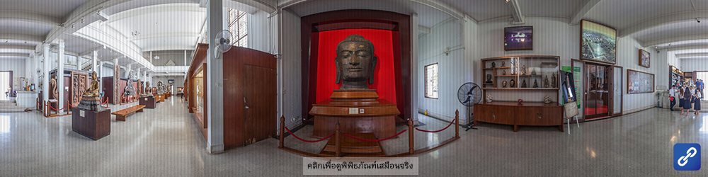
เศียรพระพุทธรูปวัดธรรมิกราช ปัจจุบันจัดแสดงที่พิพิธภัณฑ์สถานแห่งชาติเจ้าสามพระยา
(จำนวนผู้เข้าชม 987 ครั้ง)
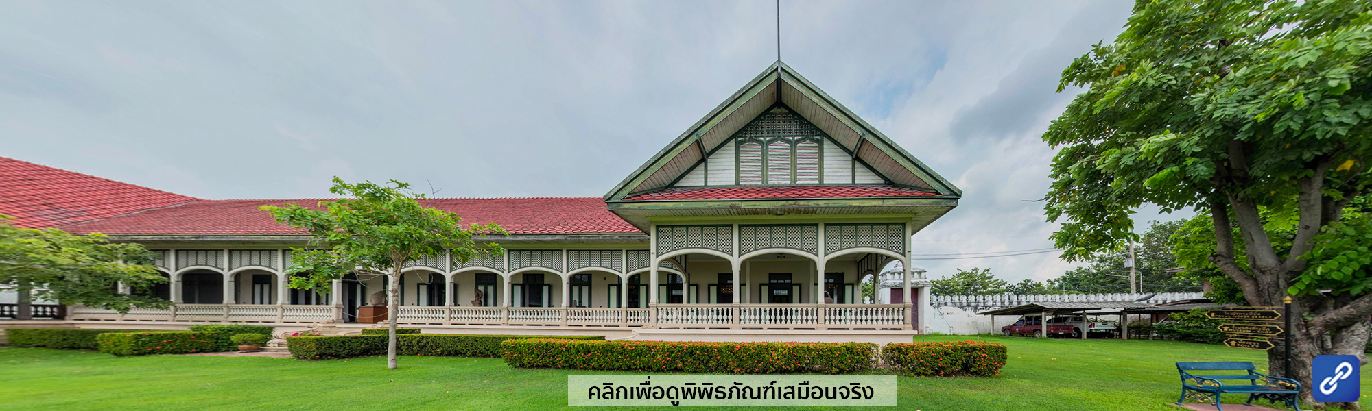
พระราชวังจันทรเกษม ตั้งอยู่บริเวณริมแม่น้ำป่าสัก หรือ ที่เรียกว่า คูขื่อหน้า ในอดีตทางด้านทิศเหนือ มุมตะวันออกของเกาะเมืองอยุธยา ใกล้กับตลาดหัวรอ ตำบลหัวรอ อำเภอพระนครศรีอยุธยา จังหวัดพระนครศรีอยุธยา หลักฐานตามพระราชพงศาวดารสันนิษฐานได้ว่า พระราชวังจันทรเกษม หรือวังหน้า สร้างขึ้นในรัชสมัย สมเด็จพระมหาธรรมราชา ประมาณ พุทธศักราช ๒๑๒๐ ด้วยมีพระราชประสงค์เพื่อให้เป็นที่ประทับของสมเด็จพระนเรศวรมหาราช เมื่อทรงดำรงตำแหน่งพระมหาอุปราชครองเมืองพิษณุโลก
นอกจากนี้ยังเคยเป็นที่ประทับของพระมหากษัตริย์และพระมหาอุปราชที่สำคัญถึง ๘ พระองค์ คือ
- สมเด็จพระนเรศวรมหาราช
- สมเด็จพระเอกาทศรถ
- เจ้าฟ้าสุทัศน์
- สมเด็จพระนารายณ์มหาราช
- ขุนหลวงสรศักดิ์ (พระเจ้าเสือ)
- สมเด็จพระเจ้าอยู่หัวท้ายสระ
- สมเด็จพระเจ้าบรมโกศ
- กรมพระราชวังบวรมหาเสนาพิทักษ์
ภายหลังเสียกรุงศรีอยุธยาครั้งที่ ๒ ใน พุทธศักราช ๒๓๑๐ พระราชวังจันทรเกษม ได้ถูกทิ้งร้างไป จนกระทั่งในรัชสมัย พระบาทสมเด็จพระจอมเกล้าเจ้าอยู่หัว รัชกาลที่ ๔ แห่งกรุงรัตนโกสินทร์ จึงได้มีการบูรณะและปรับปรุงพระราชวังจันทรเกษมขึ้นใหม่ เพื่อใช้สำหรับเป็นที่ประทับในเวลาที่พระองค์เสด็จประพาสพระนครศรีอยุธยา และพระราชทานนามว่า พระราชวังจันทรเกษม
ต่อมา พระบาทสมเด็จพระจุลจอมเกล้าเจ้าอยู่หัว รัชกาลที่ ๕ ได้พระราชทานพระราชวังจันทรเกษม ให้เป็นที่ทำการของมณฑลกรุงเก่า โดยใช้ พระที่นั่งพิมานรัตยา ซึ่งเป็นหมู่ตึกกลางของพระราชวังเป็นที่ทำการ
เมื่อพระยาโบราณราชธานินทร์ได้เข้ามาดำรงตำแหน่งสมุหเทศาภิบาลมณฑลกรุงเก่า ได้จัดสร้างอาคารที่ทำการภาคบริเวณกำแพงวัง ด้านทิศตะวันตกต่อกับทิศใต้ แล้วย้ายที่ว่าการมณฑลจากพระที่นั่งพิมานรัตยา มาตั้งที่อาคารที่ทำการภาคในขณะนั้น
วังจันทรเกษม มิวเซียมที่กรุงเก่า
ในระหว่างที่พระยาโบราณราชธานินทร์ ดำรงตำแหน่งสมุหเทศาภิบาล มณฑลอยุธยา ท่านได้ทำการศึกษา และรวบรวมเรื่องราว รวมทั้งวัตถุสิ่งของสำคัญในบริเวณกรุงเก่า และบริเวณใกล้เคียงไว้เป็นจำนวนมาก มาเก็บรักษาไว้ที่พระราชวังจันทรเกษม จนกระทั่งในปีพุทธศักราช ๒๔๕๕ สมเด็จฯ กรมพระยาดำรงราชานุภาพ ได้ทรงแนะนำให้พระยาโบราณราชธานินทร์ จัดตั้งพิพิธภัณฑ์ เรียกว่า "โบราณพิพิธภัณฑ์" โดยในระยะแรกนั้นใช้ตึกโรงม้าพระที่นั่งเป็นที่เก็บรวบรวม
ต่อมาเมื่อวันที่ ๒๓ กุมภาพันธ์ พุทธศักราช ๒๔๔๗ พระบาทสมเด็จพระจุลจอมเกล้าเจ้าอยู่หัว มีพระราชดำริโปรดเกล้าฯ ให้ย้ายวัตถุต่าง ๆ จากโรงม้าพระที่นั่งเข้ามาเก็บรักษาและตั้งแสดงที่บริเวณอาคารพลับพลาจัตุรมุข พร้อมทั้งจัดสร้างระเบียงตามแนวอาคารด้านทิศเหนือ และทิศตะวันออก เพื่อจัดตั้งวัตถุ ศิลาจารึก และประติมากรรรมต่าง ๆ ตั้งชื่อว่า "อยุธยาพิพิธภัณฑ์"
พุทธศักราช ๒๔๑๕ พระบาทสมเด็จพระจุลจอมเกล้าเจ้าอยู่หัว เสด็จประพาสยุโรป เมื่อเสด็จถึงเมืองฮอมเบิค ประเทศเยอรมนี ทรงมีโทรเลขถึงสมเด็จฯ กรมพระยาดำรงราชานุภาพ ความว่า "มิวเซียมที่นี่เหมือนมิวเซียมที่กรุงเก่า" ด้วยเหตุนี้เอง "อยุธยาพิพิธภัณฑ์" ในขณะนั้น จึงเป็นที่รู้จักของบรรดาผู้สนใจ และรักในงานด้านประวัติศาสตร์โบราณคดีของชาติ
ต่อมา ในวันที่ ๑๒ กุมภาพันธ์ ๒๔๗๙ กรมศิลปากร ได้ประกาศให้อยุธยาพิพิธภัณฑ์เป็นพิพิธภัณฑสถานแห่งชาติ ในนาม "พิพิธภัณฑสถานแห่งชาติ จันทรเกษม
นิทรรศการ
ปัจจุบันได้มีการจัดแสดง นิทรรศการถาวรภายในพระที่นั่งและอาคารต่าง ๆ ดังนี้
พลับพลาจัตุรมุข

เป็นห้องที่ระลึก พระบาทสมเด็จพระจอมเกล้าเจ้าอยู่หัว รัชกาลที่ ๔ จัดแสดงเครื่องใช้ส่วนพระองค์ ที่มีอยู่เดิมภายในพระราชวังแห่งนี้ ได้แก่ พระแท่นบรรทม พระราชอาสน์พร้อมเศวตฉัตร พระบรมฉายาลักษณ์ และเครื่องราชูปโภคต่างๆ ที่หาชมได้ยาก
พระที่นั่งพิมานรัตยา
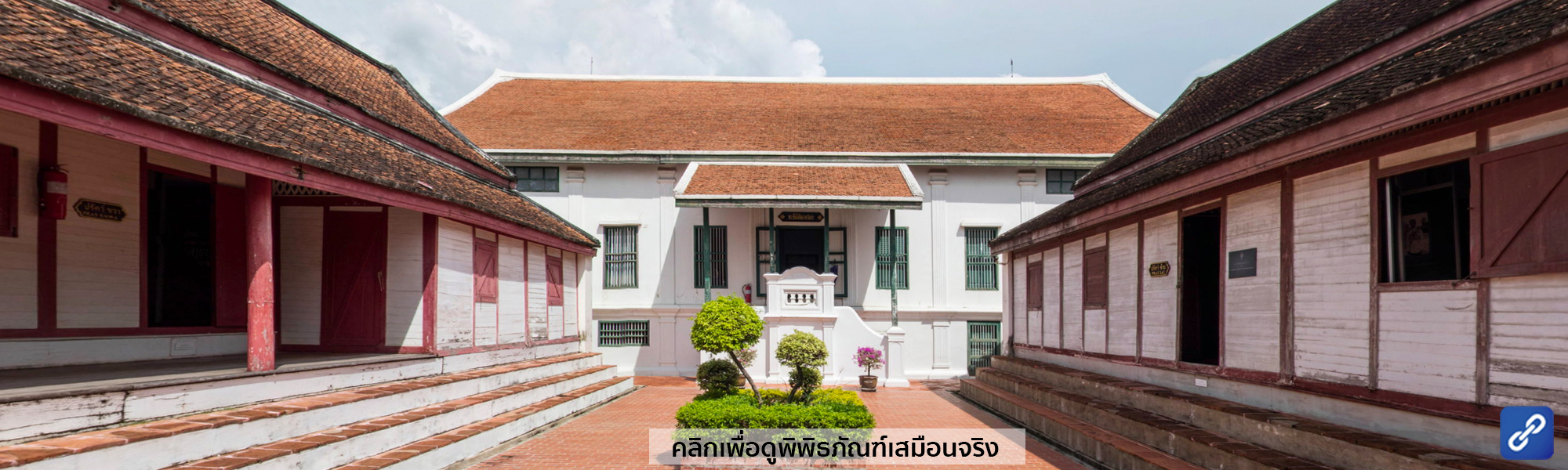
จัดแสดงโบราณศิลปวัตถุสมัยต่าง ๆ ที่พระยาโบราณราชธานินทร์เก็บรวบรวม ได้แก่ ประติมากรรมที่สลักจากศิลา เช่น เทวรูปและพระพุทธรูปนาคปรก ศิลปะสมัยลพบุรี กลุ่มพระพุทธรูปสำริด สมัยอยุธยา ที่พบในพระพาหาซ้ายของ พระมงคลบพิตร และพระพุทธรูปทรงเครื่องสมัยอยุธยาตอนปลายที่มีความวิจิตรงดงาม รวมทั้งพระพิมพ์แบบต่าง ๆ ที่พบจากกรุวัดมหาธาตุและวัดราชบูรณะ นอกจากนี้ยังมีเครื่องไม้จำหลักฝีมือช่างอยุธยาตอนปลาย และรัตนโกสินทร์ตอนต้น ที่ประณีตงดงามอีกหลายชิ้น จัดแสดงรวมอยู่ด้วย
อาคารมหาดไทย
"อาคารมหาดไทย หรือ ตึกที่ทำการภาค เป็นอาคารรูปตัว L ก่ออิฐถือปูน หลังคามุงกระเบื้อง ตั้งอยู่ชิดกำแพงพระราชวังด้านทิศตะวันตกต่อกับทิศใต้ ขนาดกว้าง ๑๐ เมตร ด้านทิศตะวันตกยาว ๕๐ เมตร ด้านทิศใต้ยาว ๖๕ เมตร สร้างขึ้นในสมัยรัชกาลที่ ๖ ครั้งพระยาโบราณราชธานินทร์ (พร เดชะคุปต์) เป็นสมุหเทศาภิบาลมณฑลกรุงเก่า ใช้เป็นตึกที่ทำการภาคต่อมาจนกระทั่งเปลี่ยนแปลงการปกครอง พุทธศักราช ๒๔๗๕ หลังจากนั้นยังได้ใช้เป็นที่ทำการของอัยการจังหวัด สำนักงานตรวจเงินแผ่นดิน สำนักงานสหกรณ์จังหวัด และสำนักงานคลังเขต ๑ จนกระทั่ง พุทธศักราช ๒๕๓๖จึงได้ส่งคืนให้เป็นที่ทำการของพิพิธภัณฑสถานแห่งชาติ จันทรเกษม
หอพิศัยศัลลักษณ์ (หอดูดาว)
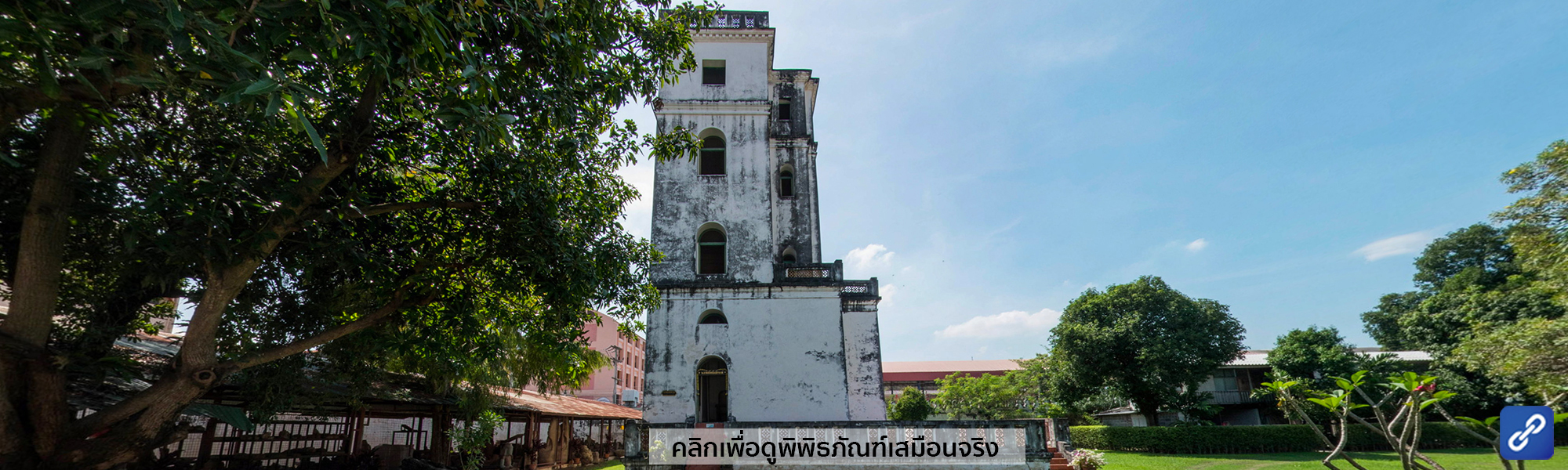
หอพิศัยศัลลักษณ์ เป็นอาคารทรงหอ ๔ ชั้นขนาดของ ๑๕.๘๐ เมตร x ๑๗ เมตร สูง ๒๒ เมตร อาคารตั้งอยู่ริมกำแพงทางด้านทิศตะวันออกเฉียงใต้ ได้รับการสันนิษฐานว่า สร้างขึ้นเป็นครั้งแรกในรัชสมัยของสมเด็จพระนารายณ์มหาราช และได้พังลงก่อนเสียกรุงอยุธยาครั้งที่ ๒ สมัยรัชกาลที่ ๔ โปรดเกล้าฯให้สร้างขึ้นตามรากฐานเดิมแล้วพระราชทานนามว่าหอพิสัยศัลลักษณ์ ใช้เป็นที่ประทับทอดพระเนตรดวงดาว ต่อมาเมื่อพื้นที่ภานในพระราชวังจันทรเกษม ถูกใช้เป็นที่ทำการมณฑลกรุงเก่า จึงทำหน้าที่เป็นหอสังเกตุการณ์และติดเครื่องสัญญาณเตือนภัยของมณฑลกรุงเก่า
ศาลาเชิญเครื่อง
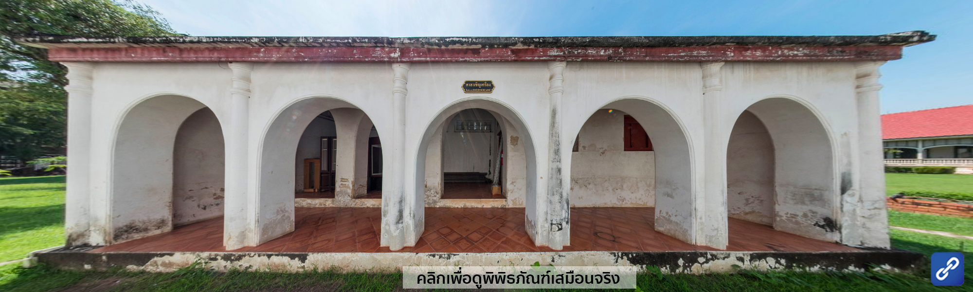
ตั้งอยู่ทางด้านทิศใต้ของกลุ่มพระที่นั่งพิมานรัตยา เป็นลักษณะอาคารแบบโถงตะวันตกหลังคามุงกระเบื้อง หอพิสัยศัลลักษณ์ เป็นอาคารทรงหอ ๔ ชั้น ขนาด ๑๕.๘๐ เมตร x ๑๗ เมตร สูง ๒๒ เมตร ตั้งอยู่ริมกำแพงด้านทิศตะวันออกเฉียงใต้ สันนิษฐานว่าสร้างครั้งแรกในสมัยสมเด็จพระนารายณ์มหาราช และได้พังลงตั้งแต่ก่อนเสียกรุงศรีอยุธยาครั้งที่ ๒ สมัยรัชกาลที่ ๔ โปรดเกล้าฯ ให้สร้างขึ้นตามรากฐานเดิมแล้วพระราชทานนามว่า หอพิสัยศัลลักษณ์ ใช้เป็นที่ประทับทอดพระเนตรดวงดาว ต่อมาเมื่อพื้นที่ภายในพระราชวังจันทรเกษม ถูกใช้เป็นที่ทำการมณฑลกรุงเก่า จึงทำหน้าที่เป็นหอสังเกตุการณ์และติดเครื่องสัญญาณเตือนภัยของมณฑลกรุงเก่า
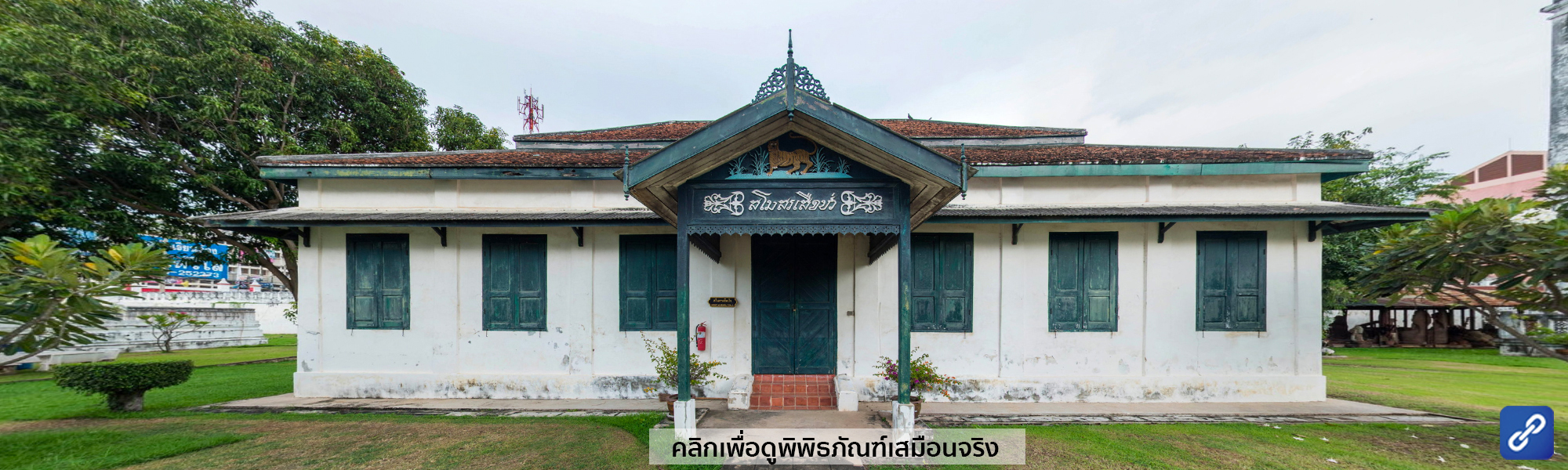
อาคารสโมสรเสือป่า
เป็นอาคารก่ออิฐถือปูน ทรงปั้นหยาชั้นเดียว หลังคามุงกระเบื้อง ขนาด ๑๑.๒๐ เมตร x ๒๐ เมตร ตั้งอยู่ด้านหลังพระที่นั่งพิมานรัตยา สร้างขึ้นในสมัยรัชกาล พระบาทสมเด็จพระมงกุฎเกล้าเจ้าอยู่หัว ใช้สำหรับเป็นที่ชุมนุมกองเสือป่าของมณฑลกรุงเก่า ภายหลังเป็นที่ตั้ง "สำนักงานหอสมุดแห่งชาติ"
โรงม้าพระที่นั่ง
เป็นอาคารก่ออิฐถือปูน ขนาด ๖ เมตร ๑๗ เมตร ตั้งอยู่ริมกำแพงด้านทิศตะวันตกเฉียงเหนือ สร้างสมัยรัชกาลที่ ๔ ในสมัยรัชกาลที่ ๕ พระยาโบราณราชธานินทร์ ใช้เป็นที่ตั้ง โบราณพิพิธภัณฑ์
(จำนวนผู้เข้าชม 671 ครั้ง)
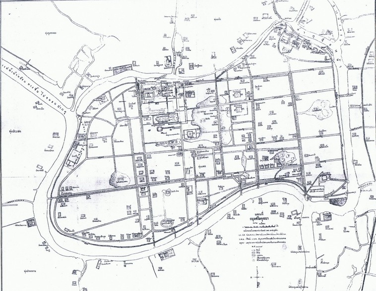
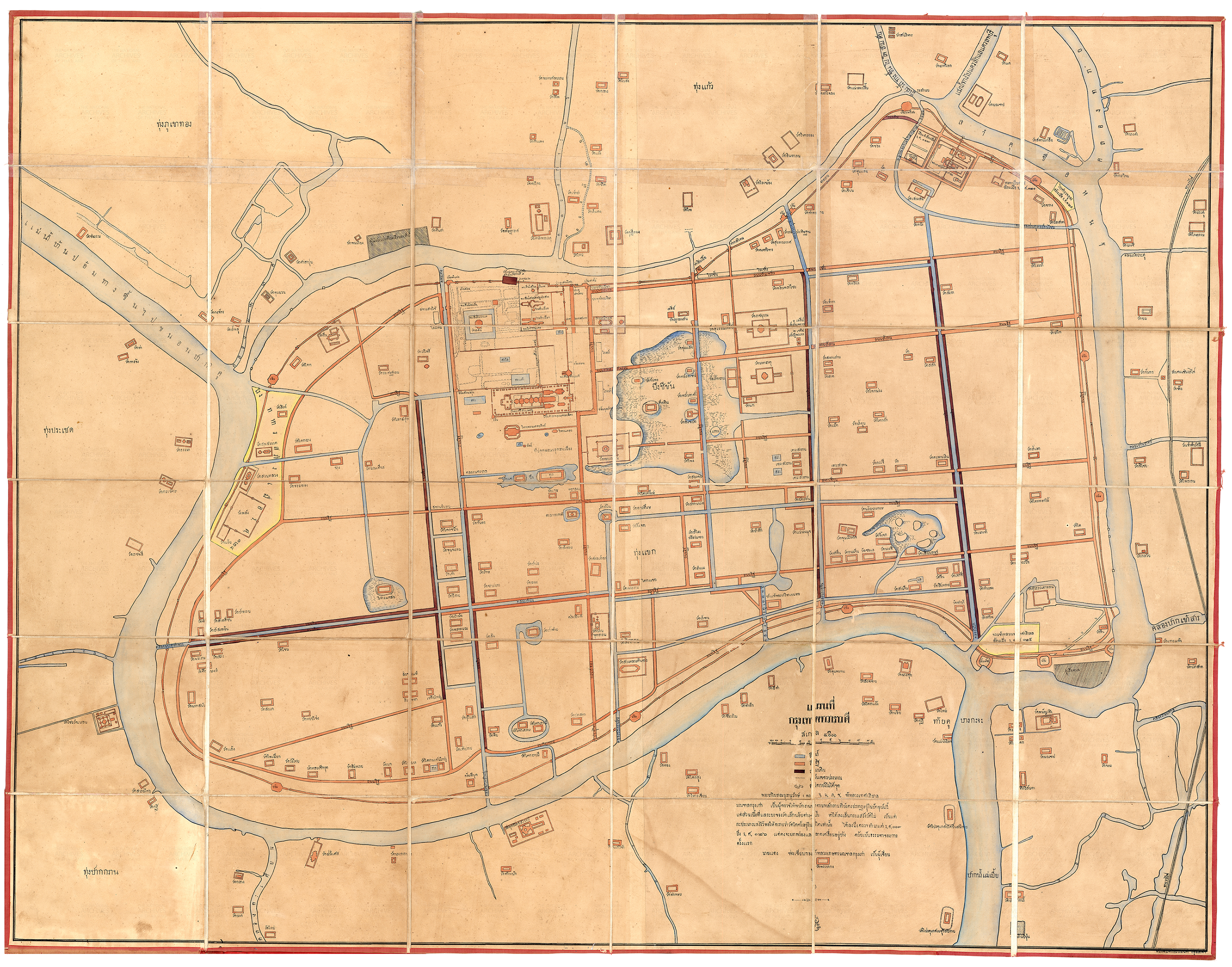
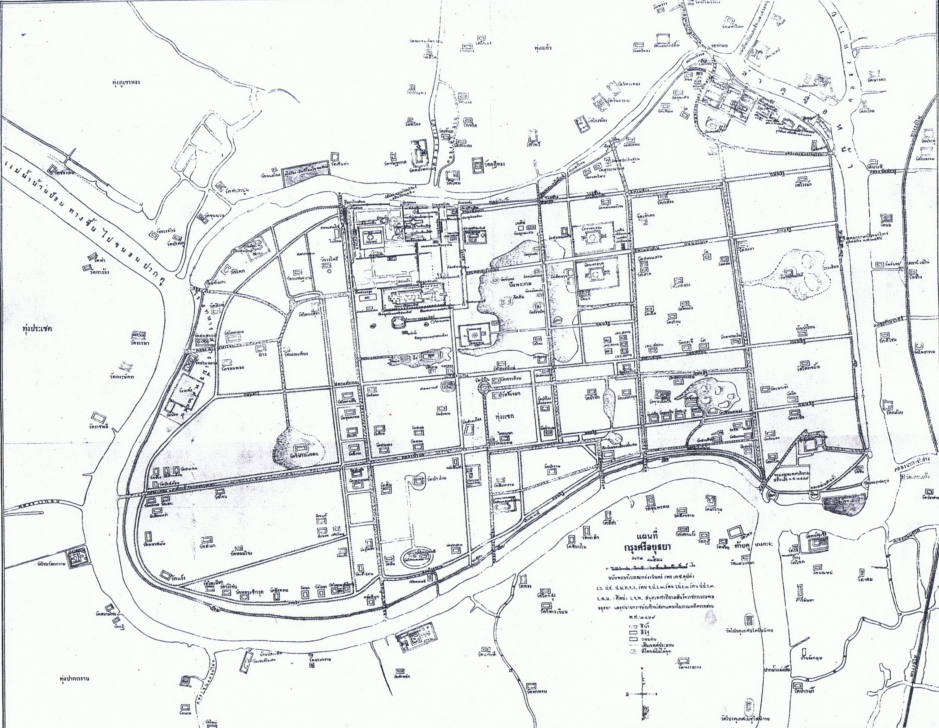
การจัดทำแผนที่กรุงศรีอยุธยาพระยาโบราณราชธานินทร์ ได้จัดทำแผนที่กรุงศรีอยุธยา ๒ ฉบับ ได้แก่ แผนที่กรุงเทพทวารวดี พ.ศ. ๒๔๕๐ และแผนที่กรุงศรีอยุธยา พ.ศ. ๒๔๖๙ แผนที่ทั้งสองฉบับนี้ถือเป็นแผนที่สำรวจผังเมืองสมัยใหม่ เขียนตามหลักวิชาการการทำแผนที่แบบตะวันตก ทำให้มีความน่าเชื่อถือเรื่องความถูกต้องแม่นยำและแสดงสภาพภูมิสถานได้ดีกว่าแผนที่โบราณ ใช้เป็นฐานข้อมูลอ้างอิงสำหรับการศึกษาประวัติศาสตร์และโบราณคดีอยุธยาจนถึงปัจจุบัน |
|
|
แผนที่กรุงเทพทวาราวดี พ.ศ. ๒๔๕๐เป็นแผนที่กรุงเก่าที่พิมพ์โดยกรมแผนที่ รูปสี่เหลี่ยมผืนผ้า กว้างประมาณ ๑ เมตร ยาว ๑.๒๐ เมตร มาตราส่วน ๑:๕,๐๐๐ มีแถบมาตราส่วนบอกระยะความยาวเป็นเส้น ใช้สัญลักษณ์เป็นรูปสี่เหลี่ยมผืนผ้าเล็ก ๆ ระบายสีลงในรูปต่างกัน ตามด้วยคำอธิบายว่าสีน้ำ สีอิฐ ถนนดิน เขียนเส้นประเล็ก ๆ ว่าเป็นเส้นเขตร์ประมาน และสุดท้ายเป็นวงกลมรูปไข่ ภายในมีจุดเล็ก ๆ เหมือนไข่ปลา ซึ่งหมายถึงที่โคกเนินยังไม่ได้ขุด ในแผนที่แสดงที่ตั้งของวัด สถานที่ราชการสำคัญพร้อมปีสร้าง ดังเช่น จวนข้าหลวงเทศาภิบาลสร้างเมื่อ ร.ศ. ๑๒๕ หอทะเบียนสร้างเมื่อ ร.ศ. ๑๒๑ เป็นต้นแผนที่ฉบับนี้พระยาโบราณบุรานุรักษ์ (พร เดชะคุปต์) ข้าหลวงเทศาภิบาลมณฑลกรุงเก่าเป็นผู้ตรวจให้พนักงานทำตามหลักฐานที่ยังคงปรากฏอยู่ในปัจจุบันนี้ โดยมีนายแดง ช่างเขียนกองข้าหลวงเกษตร มณฑลกรุงเก่า เป็นผู้เขียน ใช้เวลาทำถึง ๙ ปี ตั้งแต่ ร.ศ. ๑๑๗ (พ.ศ. ๒๔๔๑) ถึง ร.ศ. ๑๒๖ (พ.ศ. ๒๔๕๐) ซึ่งเป็นปีที่พระบาทสมเด็จพระจุลจอมเกล้าเจ้าอยู่หัวทรงครองสิริราชสมบัติครบ ๔๐ ปี |
|
|
แผนที่กรุงศรีอยุธยา พ.ศ. ๒๔๖๙เป็นแผนที่ที่พระยาโบราณราชธานินทร์ (พร เดชะคุปต์) ได้จัดทำขึ้นในขณะดำรงตำแหน่งเป็นสมุหเทศาภิบาลสำเร็จราชการมณฑลอยุธยา และอุปนายกราชบัณฑิตยสภา แผนกโบราณคดี ตรวจสอบเมื่อ พ.ศ. ๒๔๖๙ เป็นแผนที่เขียนด้วยลายมือ มีขนาดกว้าง ๓๕ เซนติเมตร ยาว ๔๒ เมตร มาตราส่วน ๑:๑๑๕๓๐ มีแถบมาตราส่วนบอกระยะความยาวเป็นเส้น ใช้สัญลักษณ์เช่นเดียวกับในแผนที่กรุงเทพทวาราวดีแผนที่ฉบับนี้เป็นการสำรวจและเผยแพร่ข้อมูลบริเวณเกาะเมืองขึ้นใหม่ใน พ.ศ. ๒๔๖๙ มีความถูกต้องและแม่นยำยิ่งขึ้น ได้แสดงตำแหน่งวัด สถานที่ราชการหลายแห่งพร้อมด้วยปีสร้าง เช่น จวนสมุหเทศาภิบาล สร้างเมื่อ พ.ศ. ๒๔๔๙ หอทะเบียนสร้าง พ.ศ. ๒๔๔๕ และโรงเรียนจอมสุรางค์อุปถัมภ์ สร้างเมื่อ พ.ศ. ๒๔๖๑ เป็นต้น |
|
องค์การศึกษา วิทยาศาสตร์ และวัฒนธรรมแห่งสหประชาชาติ (UNESCO) มีมติให้ประกาศขึ้นทะเบียน นครประวัติศาสตร์พระนครศรีอยุธยา เป็น “มรดกโลก” เมื่อวันที่ ๑๓ ธันวาคม พ.ศ.๒๕๓๔ เป็นมรดกทางวัฒนธรรมของไทยที่จะสืบทอดเป็นแหล่งเรียนรู้ของโลกสากล จึงเห็นควรเสนอองค์การยูเนสโก (UNESCO) ร่วมเฉลิมฉลองในวาระครบ ๑๕๐ ปี ชาตกาล พระยาโบราณราชธานินทร์ (พร เดชะคุปต์) ในวันที่ ๒๘ กุมภาพันธ์ พ.ศ. ๒๕๖๕
|
(จำนวนผู้เข้าชม 2590 ครั้ง)